UMARS – Unmanned Modular Airborne Research System, is a “research platform for near-ground atmospheric research,” according to its developers, IMES (Institut für Mechanische Systeme) and the ZAV ( Centre for Aviation and Transport Systems) in Switzerland.
UMARS can operate as a radio-controlled aircraft or autonomously, and carries sensors that can collect information on wind strength and direction, temperature, dewpoint, and other atmospheric parameters. Its applications can include geodetic measurements and “relief for natural disasters” such as forest fire monitoring.
Its small size allows operations without prepared runways, enabling it to be launched close to target areas, giving it greater time for observation and data collection. Autopilot subsystems for autonomous flights are under development, and will enable UMARS use by relatively untrained “pilots.” Recent deployment of an emergency parachute system shows that the airplane can be retrieved as needed.
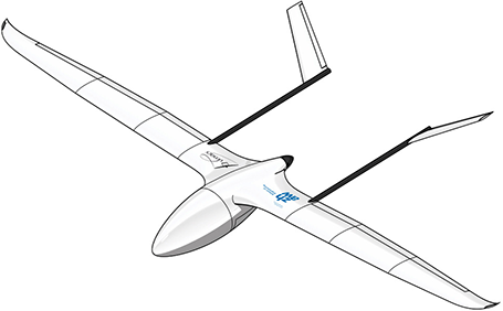
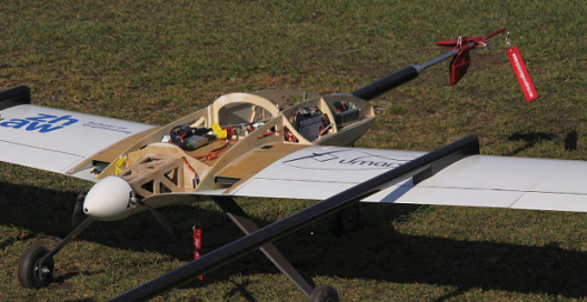
It has gone through at least two basic configurations, the first with a centrally-joined inverted V tail between its twin booms, and the latest with separated tail feathers oriented outward at a 45-degree angle from each boom.
Originally powered by a small internal combustion engine, UMARS now has an electric motor, providing a smoother platform for precise data acquisition. The electric motor and gear box are driven by 24 lithium polymer batteries arranged in two parallel rows of 12 cells in series, giving a capacity of 500 Watt-hours. The motor can draw up to 3 kilowatts, but cruises on only 400 Watts, giving a potential run time of an hour after a takeoff and climb to altitude.
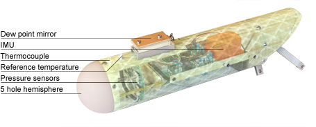
The “Z Probe” is a short, lightweight sensor boom for boundary layer research, sorting out the micro-meterology of an area, sampling air every tenth or twentieth of a second. At the speed the airplane flies, this could collect air data every few feet, giving a discrete view of very small areas.
ZHAW wants to expand the Z Probe’s capabilities. “The next step will be to integrate other existing sensors. This will start with an aerosol counter, a fast NO2 sensor and a CO2 sensor head. Of course also other sensors are possible to integrate. However, our approach is not to build what might seem possible, and then looking for applications. We are rather focusing on known scientific questions and then try to tailor a system for the specific purpose. This might include remote sensing and also optical methods (absorption) for faster in-situ measurements.”
The Z Probe incorporates a small, lightweight GPS-assisted MEMS (micro electro-mechanical system)-based Attitude and Heading Reference System (AHRS). The XSens MTi-G measures 6 degrees of freedom (DOF), provides inertial guidance and includes a static pressure sensor. It can provide outputs that give 3D Orientation (360°), position, velocity, and acceleration, rate of turn and magnetic field information to enable UMARS to stay on track and oriented.
The airplane and sensor systems have been designed and built under the guidance of Professor Dr. Hanfried Hesselbarth, Head of Lightweight Design and Lecturer for Mechanics and Lightweight Design; and Professor Dr. Bruno Neininger, lecturer Atmosphere & Meteorology in the Zurich University of Applied Science’s aviation program.
The potential for atmospheric research and monitoring of emergency situations at low cost makes UMARS a desirable asset for cash-strapped government agencies or even commercial enterprises. Its multiple capabilities show the extent to which miniaturization is making high-quality data acquisition possible. The small craft’s flight capabilities make it possible to gather this data without endangering a human pilot or crew.


Comments 1
great uav!